Vespa Alp-Cross Italia – Germania 2015
“La vita è un bel giro”
Von der Toskana in den Schwarzwald
Camaiore (Toscana) – Freiburg (Germany / Black Forest)
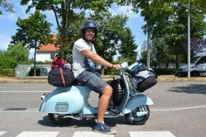
Nicht etwa klassisch per Autotransport, sondern auf den eigenen 2 Rädern sollte die in der Nähe von Livorno gekaufte Vespa VNB (Baujahr 1960) in die neue Heimat gebracht werden. So wurde aus dem Kauf auch gleich eine schöne Vespa-Tour – von der Toskana in den Schwarzwald.
Angemeldet auf meinen italienischen Freund und nach einigen Checks ging es zum TÜV. Nachdem auch die Abgasuntersuchung, die in Italien auch bei älteren Rollern wohl gemacht wird, und die VNB ohne Austausch von Sensoren oder Testgeräten bestand (anders ein Suzuki Plastikroller zuvor), konnte es losgehen.
Mit italienischem Nummernschild und frischen TÜV ging es bei bestem Sonnenschein auf die „Überführungsfahrt“ aus der Gegend Luccas nach Freiburg – rund 800 km über die Alpen nach Norden.
Day 1: Camaiore – Lodi (259 km)
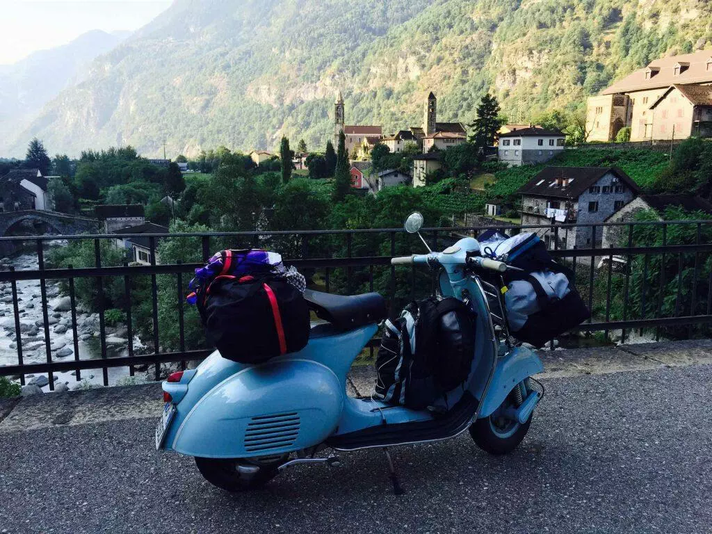
I finished packing my vespa: a backpack with all documents and adac maps, 2 bags (around 30 kg – around 10 kg my 2 chain joints, oil, tools) and my 3 l petrol can and 2 l water for my personal tank with me.
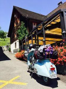
9.30 h – start of my adventure with my old Vespa 125 (VNB1 / 1960) in Camaiore.
Around 800 km to go to my final destination in Freiburg.
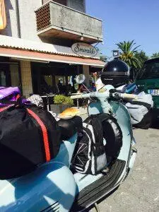
It was really hot and I stopped at Pasticceria Smeraldo (Camaiore LU) to get a little extra power – the best Pasticceria in that region – and have a last coffee, cornetto and a rum cake. A really delicious cake, you have to try it…
Then the tour really started and I drove northwards (direction La Spezia) along the nice green hills of Alpi Apuane – passing Pietrasanta, Massa and Carrara.
During the first kilometers my ears noticed every noise of the engine and every click of the gears – I crossed the fingers, that my old blue lady is strong enough to bring me over the 259 km safe & without any problems and to my first stage destination Piazenca.
Behind Sarzana (after 39 km) I drove to the East and took the SR62, direction Aulla. The climb started alone the Fiume Magra, crossing the Appennino Tosco Emiliano. It was a lot colder and the panorama was really beautiful – still around 40 km to go to Portemoli.
The road winded along the river in the Taro Valley at the Appenin mountains. Behind the historical town Pontremoli I took the autostrada and not the well-known Passo della Cisa because of saving the energy / power of my Vespa a little bit on the first day. The day with the longest planned distance. The Passo della Cisa is a part of an old european trading route from London to Roma.

I drove roundabout 30 km on the autostrada (my highest point of the day: 757 m) and they were a big adventure, because of my slow speed (it went uphill), a slower car with a caravan, a lot of tunnels, crazy italian drivers – high speed & special cornering…
I was happy to leave the highway at Borgotaro and to take a country road (SP19) downwards along the Fiume Taro. It was a really nice region – especially the growing riverbed was impressive to me.
On the SS308 I passed Stazione Valmozzola and Fornovo Di Taro. In Ramola I took the SS357 to Medesano and Noceto. It became hotter and hotter – then it was lunchtime. Behind Noceto I drove northwards on the SS9 – to Fidenza. The hottest and most boring parts of the tour started. Hill land and cornfields as far as you can see. The big advantage of that lunch: afterwards I was able to drive fast and relaxed.
In Fiorenzuola d’Arda the first petrol stop was neccessary and I took a water stop to refill my water tank in the italian heat.
At this time I decided to drive a few kilometer longer – to Lodi – 45 km more than planned. I booked a room on booking.com in Agriturismo.
At 3:30 pm – after 259 km and 6:14 h drive – I arrived at my planned destination Lodi.
It was a great first day with beautiful impressions of different landscapes and a big experience: heat is not a problem for a Vespa.
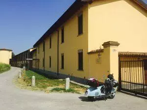
I was really happy – my old and brave blue lady brought me safe to Agriturismo Cavrigo in Lodi. A really nice farm with beautiful rooms, a friendly owner and tasty breakfast.
I was looking forward for a cold shower and a cold beer!
Facts of the day:
Distance: 259,4 km
Travel duration: 6:13 h/m
Highest speed: 73 km/h
Average speed: 41 km/h
Highest travel point: 757 m
Upwards: 1.304 m
Night 1: Agriturismo Cavrigo / Lodi (next to Milano)
A really nice farm with beautiful rooms, a friendly owner and tasty breakfast. Very fair prices! I can really recommend this hotel!
Tour Day 2: Lodi – Monza – Bellinzona (182 km)
Already in the morning it was really hot (around 25 C at 7.00 am).
After a tasty breakfast I started the 2nd tour day. Alps, I’m coming! Hopefully it will have cooler temperatures.
I started my way at 8:15 am and drove to Monza and passed Adda River, Riolo and Dovera on the SS472. Cornfields wherever I looked. But the view changed after 20 km.
The closer I got to Monza and Milano the more industrial parks appeared and the traffic got heavier. Many trucks made the driving difficult and a bit dangerous.
In Arzago D’Adda I changed the road and drove to the East on SP185. In Rivolta D’Adda I drove on SP14 and crossed the large Adda River again. I drove to Liscate, to North Melzo and to Gorgonzola on SP13. After Caponago there were only cars on the street – it was rush hour time – and so I made use of a big advantage of a Vespa and just went trough all these cars.
It was crazy – but somehow there were many nice situations, because some drivers beckonned me and showed me their thumbs-up.
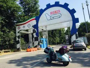
After crossing Agrate Brianza I finally reached Monza. What do you associate with Monza? Fomula 1 of course!
I drove through the huge royal park – Parco Regionale della Valle del Lambro – it was fantastic and comparable with the Central Park in NY. Many old trees, meadows, sport fields and a lot of italians doing sports. It was a lot cooler than on the road in the industrial parks.
After a few kilometers and some interesting parting of the ways I arrived at the autodromo Monza – in the middle of the park. One of the most important and historical race tracks of the world.
I used my time walking around. I had a great view on the racing track and drank a lot of water. I also gave my brave blue lady a little pause.
With many historical impressions I started my last 100 km for the 2nd tour day.
It was very difficult to find the way – the next roundabout 30-40 km – I was struggling with small roads, too little signs and many closed roads because of road work. So in the end I drove zigzag and in addition to my ADAC map I used google maps on my iPhone.
I passed an area with many small towns with small meadows and cornfields inbetween. I passed Lissone, Desio, Meda, Lentate Sul Seveso and Lazzate. In Bregnano I took a second petrol stop and did a short Vespa check. And I tried to find out where exactly I am.
Good news – I wasn’t far away from my planned route. In Lomazzo I was back on track and – I followed the SP23 – drove through Appiano Gentile, Beregazzo and Olgiate Comasco… Very cool: In the distance I saw the first mountains of the Alps – the last kilometers in Bella Italia.
After 120 km – and 379 km in Italy – I crossed the border to Switzerland at Bizzarone. Ciao Bella Italia and Grüezi Schwitzerland!
Interesting: many things are more expensive in Switzerland than in Italy/Germany – petrol is much cheaper!
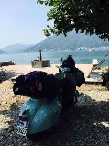
On the road again I drove through Mendrisio and reached Lago di Lugano after a few kilometers. One of the most beautiful parts of the whole tour – driving along the lake.
I stopped at Bissone and enjoyed the fantastic panorama – and ate the rest of my italian ’salami e pane’…
After this nice break I continued my drive along the lake and enjoyed the view on the mountains. I arrived at Lugana after 9 km. I went uphill and I will soon approach Bellinzona. But before that I had to drive the Monte Ceneri, so I followed the road 2 next to the highway.
Wow: When I reached the pass, there was a great view on the valley of Locarno and Bellinzona.
I drove down the serpentines very fast and reached Bellinzona after 182 km and 6:45 h travel time. It was 15:00 p.m. and extremly hot again – a thermometer showed 42 °C!
During my petrol stop and tecnical check I took a short look on the website booking.com. I found a „small“ hotel (Hotel Gamper) with an own parking flat in Bellinzone downtown, next to the train station. When I saw the prices – I again realized that I’m in Switzerland.
My brave blue Lady did a great job again and I gave her a place in the shadow to relax for the coming tour day (where we will drive upwards to the Gotthardpass).
After unpacking the Vespa and taking a cold shower I explored the beautiful Bellinzona with its historic town centre – surrounded by three amazing castles.
Facts of the day:
Distance: 182,1 km
Travel duration: 6:45 h/m
Highest speed: 73 km/h
Average speed: 26 km/h
Highest travel point: 543 m
Upwards: 1.322 m
Tour Day 3: Bellinzona – Gotthardpass – Küssnacht/Merlischachen
The peak of my Tour (175 km)
After a very warm night in the hotel – unfortunately there was no air-condition – I started my drive early with a coffee.
It was a bit cooler than the last days – the sun hid behind the mountains and the valley laid completely in shadow.

I was a bit nervous. Will my 55 years old blue lady – with 30 kg baggage & a 84 kg Vespaio – really reach the top point (the Gotthardpass in 2.106 m) of my tour?
At 7:45 am the streets were really empty and I started from Bellinzona to the Leventina Valley on the country road 2.
It’s a really beautiful and historic valley – since centuries the traders drive over the Gotthardpass to got to Italy. It’s also a part of an old european trading route from London to Roma – like the Passo Della Cisa (day 1).
The airflow was a bit cold this morning – the sun still hid behind the mountains. My jacket (the only time I had to wear it) and the fantastic alpine scenery warmed my arms and my heart.
Normally you would drive this highway with the car.
In Brisca I saw the entrance of the new Gotthard train tunnel – the world longest train tunnel with 57 km (in Erstfeld nearby the Vierwaldstättersee/Lake Lucerne) – what an impressive construction! (https://de.m.wikipedia.org/wiki/Gotthard-Basistunnel).
At the beginning it went up easily – the closer I came to Airolo, the climb of the road got steeper.
In Giornico – you could still see the mountains in the distance– the region was partly snow-covered. The Gotthardpass came closer and closer…the tension rised!
After arriving in Airolo (after 58 km) the 12 km climbing section of the historic Gotthardpass began…
(https://de.m.wikipedia.org/wiki/Gotthardpass)
Curve by curve my blue lady drove up the Gotthardpass in the warm sun – with a speed of roundabout 30-40 km/h.
What a fantastic view – I could see the Leventina Valley, the Mountains Fibbia (2.738 m), Il Madone (2.756 m), Pizzo Rotondo (3.192 m) and some other partly snow-covered mountains.
After a 22 min fight (it was hard to drive uphill) with the mountain my blue lady and I did it! We arrived happy, proud and relieved at the top of the Gotthardpass in 2.106 m!
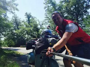
And what a surprise! Many young swiss drivers of ‚Mofa‘ also did the adventure and drove up the Gotthardpass. I also met the ‚Swiss Mofa Boys‘ and Renato, who started with his Mofa at 4:30 h from Zug.
After chatting with these guys I continued my drive 18 km downwards to Göschenen and additionaly added 67 km to my daily destination: the area of Schwyz. I passed Andermatt and Schöllenenschlucht, drove over the Teufelsbrücke and reached Göschenen in the valley.
Now one of the most surprising parts of my tour started.
I passed Reuss Valley from Altdorf to Göschenen by driving on the highway – fast and focused on the traffic! I was surprised by the beauty of the valley and the impressive massive of the mountains.
I enjoyed driving through the Reuss valleys very much. I also passed Wassen and crossed the Reuss River.
Hardly any car was on the road – it seemed as
In Erstfeld I passed the other entrance of the spectacular Gotthard train tunnel. The road crossed the train tracks.
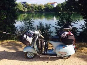
Kilometer by kilometer the valley opened up more and more and I reached Fluelen at the Vierwaldstättersee (Lake Lucerne).
Then I took the country road 2, drove on a road next to the beautiful lake and arrived at Ingenbohl and Schwyz at lunchtime after roundabout 150 km.
It was a really nice and warm day. At the petrol stop, I decided to search a hotel near to the wonderful lake. Unfortunately I forgot that I’m in Switzerland and everything is expensive!
But I was a lucky and found a special offer for the Hotel ‚Swiss Chalet Merlischachen‘ in the internet. So I booked and enjoyed!
After unpacking the Vespa and taking a cold shower I jumped right into the lake, relaxed on the beach and enjoyed the sunset and a warm evening with a cold beer!
Facts of the day:
Distance: 175,5 km
Travel duration: 6:03 h/m
Highest speed: 67 km/h
Average speed: 28 km/h
Highest travel point: 2.106 m
Upwards: 4.151 m
Tour Day 4: Küssnacht / Merlischachen – Freiburg (188,7 km)
What a beautiful morning at the Vierwaldstättersee / Lake Lucerne. Warm, but not too hot – the sun went up behind the mountain – over the lake!
At 7:45 am I started my final tour day – 188 km to go back home to Freiburg.
It was a strange feeling – nervous (does my brave blue lady hold out?), happy and proud that I did this adventure. I was looking forward to another tour day or a new tour!
So I drove on a small country road to Risch and had a last view at the Lake Zug, passing Hünenberg and Risch next to the Reuss River (do you remember yesterday’s tour section from Gotthardpass?). I enjoyed driving on an empty road in a very beautiful hilly landscape and in this nice morning atmosphere. Still 40 km to go to Brugg.
Often I thanked my blue lady for her great performance!
After crossing the Aare River in Brugg I drove on the Road 3 to the East (direction Basel). The hills got a bit higher again – I passed Effingen, Hornussen and Stein. In Stein I saw the Rhein River and the other side of it: germany! I was so excited that I took a short break … The last 80/90 km of 800 km were still laying in front of me.
And then – finally – I crossed the border to Germany in Rheinfelden. Byebye beautiful Switzerland – Willkommen Deutschland. Schön, zurück zu sein!
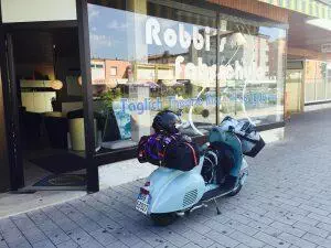
Then I drove to Lörrach and Weil am Rhein, where I made a last stop at Robbi’s Fahrschule to say hello (I made my motorcycle license there in ONE week! Thank you again for all the support there).
I started my last 60 km and my last hour of the 4-days-tour. I drove through the beautiful hilly area of the Markgräflerland (with the hills of wine). Driving on the Road L137 & B3 I passed Istein, Efringen-Kirchen and Schliengen, Auggen, Müllheim, Heitersheim, Bad Krozingen…
and nearby Ebringen my Vespa suddenly made unusual sounds: „tucktuck“. Oh, Oh…
Immediately I realized that the petrol seems to be empty – I switched to reserve mode and drove a few kilometers. I had to use 3l of my reserve tank – happy that this tank was used and there was no other problem.
Around 4:15 pm I finaly reached Freiburg (St. Georgen) – my girlfriend waited for me with her own Vespa. And the Last kilometers to Freiburg Münster we drove home together.
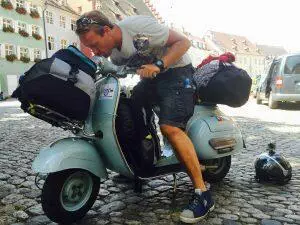
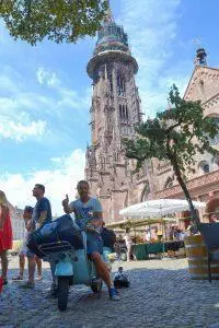
At 12:15 pm I reached the Freiburger Münster and the Alte Wache! After driving …
… 805 km in Italy, Switzerland & Germany, 23:24 (h:min) travel time,
… 7.992 m overall ascension,
… 2.105 m / St. Gotthardpass as highest travel point, my Vespa 125 VNB1 needed 21,54 l petrol.
Happy and proud we took some photos and then we drunk a tasty glas of the Badischer White Wine at the Alte Wache in the sun.
It was a really great experience and adventure – I collected many impressions, landscapes, encounters, new friends…
I am hungry for new adventures and looking forward to my next tour!
Gutedel „getauft“ – und die trockene Kehle gekühlt.
Beautiful 4 Vespa days with a VNB 125 (1960) / 814 km from Tuscany to Black forest / „Kaiserwetter“ :
„La vita è un bel giro“ oder „Life is a beautiful ride“
Facts of the day 4:
Distance: 188,7 km
Travel duration: 4:33 h/m
Highest speed: 77 km/h
Average speed: 41 km/h
Highest travel point: 562 m
Upwards: 1.209 m
Following some more impressions und datas of the Vespa Alp-Cross 2015:


Reisedaten / Traveldates
Day 1 Camaiore – Lodi
Distanz 259,4 km
Fahrtdauer 6:13 h
Höchstgeschwindigkeit 73 km/h
Durchschnittsgeschwindigkeit 41 km/h
Max Höhe 757 m / Aufstieg 1304 m
Highlight: Strecke von Massa nach Potremoli & Valmozola nach Fornova
Noceto nach Piacenza ganz flaches Ackerland: Hitze & Langweilig
Day 2 Lodi – Monza – Bellinzona
Distanz 181,1 km
Fahrtdauer 6:35 h (Rush-hour um Monza, Besichtigung Monza Rennstrecke (20min))
Höchstgeschwindigkeit 73 km/h
Durchschnittsgeschwindigkeit 26 km/h
Max Höhe 543 m / Aufstieg 1322 m
Highlight: vorab: extremer Verkehr um Monza von Lodi kommend
Durchfahrt durch Park von Monza – Monza Autodromo
Seenlandschaft von Mendrisio bis Lugano
Stadt Bellinzona
Day 3 Bellinzona – Gotthard Pass – Küssnacht/Merlischachen
Distanz 175,5 km
Fahrtdauer 6:03 h (längere Pause auf Gotthard Passhöhe Ca. 45min)
Höchstgeschwindigkeit 67 km/h
Durchschnittsgeschwindigkeit 28 km/h
Max Höhe 2105 m / Aufstieg 4157 m
Highlight: Tal von Biasca nach Airolo
Gotthardpass hoch & runter
Tal von Göschenen bis Altdorf
Fahrt Vierwaldstätter See & Zuger See
Day 4 Merlischachen – Lörrach – Freiburg
Distanz 188,7 km
Fahrtdauer 4:33 h
Höchstgeschwindigkeit 77 km/h
Durchschnittsgeschwindigkeit 41 km/h
Max Höhe 562 m / Aufstieg 1209 m
Highlight: Fahrt von Zuger See nach Brugg (Fahrt auf Höhenkamm entlang der Aargau?)
Eiken nach Rheinfelden teilweise am Rhein
B3 von Eilmedingen nach Schallstadt
__________
Zahlen der Tour / numbers & facts of the tour
Gesamtkilomter / overall kilometers: 805,7 km
Gesamtfahrtdauer / overall travel time: 23:24 h:min
Gesamtaufstieg / overall ascension: 7.992 m
Höchster Streckenpunkt / highest travel point: 2.105 m / St. Gotthardpass (Switzerland)
Höchstgeschwindigkeit / speed maximum: 77 km/h
Gepäckgewicht / Luggage weight: ca. 30-32 kg
Gesamtverbrauch / overall fuel consumption: 21,54 l
Type of Vespa: Vespa 125 (VNB1) / 1960